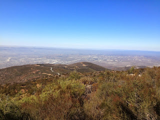
I did a quick solo ride (2.5 hours) of the Otay Truck Trail today.

The trail, southeast of San Diego, is right along the Mexican border and gives the rider some very scenic views.


This is not a difficult road for dual sport bikes or 4 wheel drive vehicles as it's mostly gravel with some red clay dirt, used and maintained by the Army Corps of Engineers, the US Border Patrol and BLM.

The Otay Truck Trail follows the ridgetops of the San Ysidro Mountains. From most of the high points, riders can see way into Mexico toward the south, the Jamul Mountains to the north, Lyons Peak to the northeast and Tecate Peak to the east. Riders can park next to the fence and actualy step into Mexico where the fence ends (not recommended).


The trail is easy because it is almost all leveled shelf road; limited passing opportunities and many blind corners are the only difficulties you will face. Numerous mirrors are positioned at blind spots to ensure you don't end up as the hood ornament on a border agent's truck.


I saw only two other vehicles on today's ride -- both 4x4s -- and passed them as I went up the hill. And while I didn't meet up with any border agents on the trail today, I was buzzed by a helicopter and a small airplane -- both USBP -- that were likely looking to see who was setting off their sensors. Once they were satisfied that my ugly orange KLR650 wasn't smuggling people or contraband, they headed off in search of more interesting things to do.
If you do go, plan for enough time to explore the many side trails that lead to observation points (mainly for border agents) along the way.
Most of them end just a few hundred yards from the main road but are interesting to follow. I ran into several "Ys" along the way and took them all. It's my policy that when presented with a "Y" I always say, "Y not."


How to get there: There are two main entrances to the Otay Truck Trail, both about 20 miles from downtown San Diego.
The north entrance is off of Otay Lakes Road, east of Lower Otay Reservoir. About 2.5 miles west of Highway 94 is the Pio Pico Country Store. The entrance to the Otay Truck Trail is on the west side of the parking lot (up the hill, not into the RV park).
The east entrance is off Highway 94, about 1.5 miles east of Dulzura, at Marron Valley Road. Follow Marron Valley Road for 2.5 miles where the Otay Truck Trail branches off to the right.
Entering or exiting at the west end can sometimes be tricky as border agents will often shut and lock the gates; no worries as there are ways around that.
 The easiest way to exit at the west end of the trail at Alta Road, not far from Donovan State Prison and the county/ferderal detention complex.*
  When you reach this exit at Alta Road, turn left and head toward the 905 an the major north/south freeways (I-5/I-805).
* NOTE: Those that know me understand why I was unfortunately in one or more of these facilities. Nuff said...

Great pictures. I've never been that south so I enjoyed the pics.
ReplyDeleteSo when the USBP helicopters come around do you wave or just ignore them.
I do wave, just to let them know I'm not a threat.
ReplyDeleteI've stopped and spoken to many of the border patrol agents when I ride along the border area. Most are very cool and are interested in dual sport riding--they have more questions about my bike than about what I'm doing in the area.
On top of that, they normally have updated info on road conditions, closed gates and fun stuff to see.
Good question!